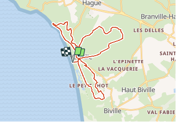
![](/images/other/stat-length.png)
![Randonnée V.T.T. La Hague - De La Crecque - Vauville au Camp Maneyrol - Circuit n° 10 - Photo](https://media.geolcdn.com/t/1900/400/ext.pjpeg?maxdim=2&url=https%3A%2F%2Fservices.sitytrail.com%2FGeolivesWS%2FDownloadMedia.ashx%3FTrailID%3D110387%26Media%3D5844_1.jpg)
De La Crecque - Vauville au Camp Maneyrol - Circuit n° 10
tracegps
Utilisateur
![Longueur](/images/other/stat-length.png)
![Altitude max](https://static1.geolcdn.com/siteimages/upload/files/1508320355ic_sort_altitude_max_24dp.png)
![Dénivelé positif](https://static1.geolcdn.com/siteimages/upload/files/1508320355ic_sort_den_pos_24dp.png)
![Km-Effort](/images/other/stat-length.png)
![Altitude min](https://static1.geolcdn.com/siteimages/upload/files/1508320355ic_sort_altitude_min_24dp.png)
![Dénivelé négatif](https://static1.geolcdn.com/siteimages/upload/files/1508320355ic_sort_den_neg_24dp.png)
![Boucle](https://static1.geolcdn.com/siteimages/upload/files/16400158638029165_repeat_loop_refresh_sync_direction_icon.png)
![V.T.T.](https://static1.geolcdn.com/sitytour/trail-icons/202.png)
1h19
Difficulté : Très difficile
![Scannez ce code QR pour ouvrir la randonnée dans l'application SityTrail](https://capi.geolives.com/qq0zvz2zws4bq2lad0pu/sitytour/trails/110387/qr.png?size=200)
Application GPS de randonnée GRATUITE
À propos
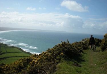
Randonnée V.T.T. de 17,4 km à découvrir à Normandie, Manche, La Hague. Cette randonnée est proposée par tracegps.
Description
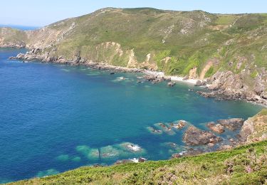
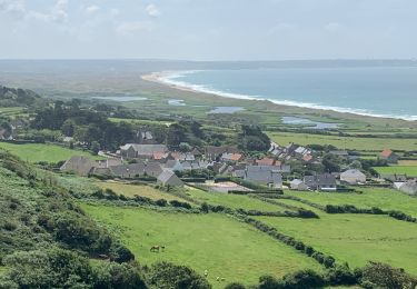
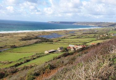
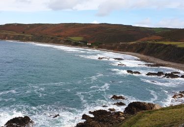
Départ : La Crecque. Ce nom Normand est issu du mot « crèche » (mangeoire pour bétail). Camp Maneyrol. Première station de vol, crée en 1923, elle porte le nom d’Alexis Maneyrol (1891-1923) en mémoire du pilote qui battit le record mondial de durée de cette époque. (Paris-Rome sans escale en 5h39) Alexis Maneyrol s’est tué en 1923 lors d’un concours en Angleterre. Il voulu dépasser les 4000 mètres d’altitude. L’avion s’écrase au sol. L’aiguille du barographe bloquée à 4200m. Pierre Pouquelées. Allée couverte, sépulture collective type armoricain érigée pendant la période néolithique (env. 4000 avant J-C) qui culmine à 134 mètres d’altitude. Ce monument est classé monument historique en 1854.
Localisation
Commentaires
Randonnées à proximité
![Randonnée Vélo La Hague - La Haguarde Bitumeuse 2011 - Gréville Hague - Photo](https://media.geolcdn.com/t/375/260/ext.jpg?maxdim=2&url=https%3A%2F%2Fservices.sitytrail.com%2FGeolivesWS%2FDownloadMedia.ashx%3FTrailID%3D106083%26Media%3D10276_1.jpg)
![Vélo Vélo](https://static1.geolcdn.com/sitytour/trail-icons/200.png)
Vélo
![](/images/other/stat-length.png)
![](https://static1.geolcdn.com/siteimages/upload/files/16400158638029165_repeat_loop_refresh_sync_direction_icon.png)
![Randonnée Marche La Hague - Séjour Cotentin Etape 4 Biville - Les Pieux - Photo](https://media.geolcdn.com/t/375/260/20c319c1-9c7e-4f29-bee7-385fa39e6485.jpg&format=jpg&maxdim=2)
![Marche Marche](https://static1.geolcdn.com/sitytour/trail-icons/101.png)
Marche
![](/images/other/stat-length.png)
![](https://static1.geolcdn.com/siteimages/upload/files/16400158638029165_repeat_loop_refresh_sync_direction_icon.png)
![Randonnée Marche La Hague - ioupi biville 01 - Photo](https://media.geolcdn.com/t/375/260/ext.jpg?maxdim=2&url=https%3A%2F%2Fstatic1.geolcdn.com%2Fsiteimages%2Fupload%2Ffiles%2F1553511878bg_sport_marche.png)
![Marche Marche](https://static1.geolcdn.com/sitytour/trail-icons/101.png)
Marche
![](/images/other/stat-length.png)
![](https://static1.geolcdn.com/siteimages/upload/files/16400158638029165_repeat_loop_refresh_sync_direction_icon.png)
![Randonnée Marche La Hague - Vauville - Photo](https://media.geolcdn.com/t/375/260/2b220e39-b1b1-4526-a0cf-9eab92539eb2.jpg&format=jpg&maxdim=2)
![Marche Marche](https://static1.geolcdn.com/sitytour/trail-icons/101.png)
![Randonnée Marche La Hague - Vauville - Côte Soufflée A/R - Photo](https://media.geolcdn.com/t/375/260/eb27b005-2ab1-4642-aace-d7963dce8dc5.jpg&format=jpg&maxdim=2)
![Marche Marche](https://static1.geolcdn.com/sitytour/trail-icons/101.png)
Marche
![](/images/other/stat-length.png)
![](https://static1.geolcdn.com/siteimages/upload/files/16400158638029165_repeat_loop_refresh_sync_direction_icon.png)
![Randonnée Marche La Hague - Gag - Photo](https://media.geolcdn.com/t/375/260/b3b09df4-3380-48d8-b0c7-2a859452b91a.jpg&format=jpg&maxdim=2)
![Marche Marche](https://static1.geolcdn.com/sitytour/trail-icons/101.png)
![Randonnée Marche La Hague - Vauville, dunes de Biville Héauville - Photo](https://media.geolcdn.com/t/375/260/26dd8ef3-68e9-4a0b-a9e4-59cc22a7a231.jpg&format=jpg&maxdim=2)
![Marche Marche](https://static1.geolcdn.com/sitytour/trail-icons/101.png)
Marche
![](/images/other/stat-length.png)
![](https://static1.geolcdn.com/siteimages/upload/files/16400158638029165_repeat_loop_refresh_sync_direction_icon.png)
![Randonnée Marche La Hague - Herquemoulin-Cap de la Hague - Photo](https://media.geolcdn.com/t/375/260/5a35c261-cb44-47dd-89d5-6c3138309710.jpg&format=jpg&maxdim=2)
![Marche Marche](https://static1.geolcdn.com/sitytour/trail-icons/101.png)
Marche
![](/images/other/stat-length.png)
![](https://static1.geolcdn.com/siteimages/upload/files/16400158638029165_repeat_loop_refresh_sync_direction_icon.png)
![Randonnée V.T.T. La Hague - La Banane à Vauville - Photo](https://media.geolcdn.com/t/375/260/ext.jpg?maxdim=2&url=https%3A%2F%2Fservices.sitytrail.com%2FGeolivesWS%2FDownloadMedia.ashx%3FTrailID%3D215233%26Media%3D15852_3.jpg)
![V.T.T. V.T.T.](https://static1.geolcdn.com/sitytour/trail-icons/202.png)
V.T.T.
![](/images/other/stat-length.png)
![](https://static1.geolcdn.com/siteimages/upload/files/16400158638029165_repeat_loop_refresh_sync_direction_icon.png)